Martell: Heartland Drought Resolving in a Stormy Winter

The following content was provided by meteorologist Gail Martell of MartellCropProjections.com:
Heartland Drought Resolving in a Stormy Winter
The weather pattern has suddenly reversed course late in the winter to generate frequent storms and heavy precipitation in the central United States. The forecast continues stormy in the heartland, featuring two new storms this week, the first one targeting the Upper Midwest and Great Lakes and the second targeting the Central Great Plains.

North Dakota is receiving heavy snow this morning that would spread into Minnesota, both key spring wheat areas in need of moisture. An elongated trough of low pressure would develop south- and eastward through across Wisconsin, Iowa, Illinois and Indiana, all expecting heavy precipitation, one-half to one inch of snow melt or cold rain.

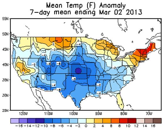
Though the calendar has turned over to March the weather does not feel like spring. The Midwest is cold and covered by snow. Temperatures have been 4-8 degrees F below normal in the U.S. heartland from a heavy snow pack. Spring planting feels a long way off due to frozen field conditions. The frost-freeze line has sunk southward, extending across southern Kansas through central Missouri and then bending north across central Illinois into northern Indiana and Ohio.
This week’s forecast continues colder than normal in the Northern Midwest while the Southern Plains gradually warms up to normal. Kansas, Oklahoma and Texas may receive more beneficial precipitation in a new storm early next week.
Southern Jet Stream Strengthening
A second wave of heavy precipitation is expected in the United States breadbasket. The GFS model forecasts a deep wave of low pressure Friday in southern California, strengthening Saturday over the Southwest U.S. Desert, eventually lifting northeastward into the Great Plains.

The preliminary forecast indicates .50-.80 inch of moisture in southern Oklahoma, but much heavier amounts in northern Oklahoma, up to 1.50 inches in central Kansas. Eastern Colorado, north Kansas and Nebraska would receive up to 2 inches of moisture. The reliability of weather forecasts rapidly diminishes 5 days into the future, but a stormy weather pattern still seems a good bet in the U.S. breadbasket March 10-12.
Hard red winter wheat drought is rapidly resolving. Back-to-back snow storms in late February produced 2-3 inches of valuable snow-water in Kansas and Oklahoma and 1-2 inches in West Texas. Drought is rapidly resolving in the U.S. breadbasket, where the winter climate is typically dry. The next storm, if it develops as expected, may even generate a moisture surplus.
El Nino Signal Emerging
A suddenly stormy weather pattern signals an emerging El Nino signal. Whereas La Nina is the drought-maker in winter, El Nino causes wetness. The Southern Great Plains especially benefits from heavy precipitation from a very strong sub-tropical jet stream.
With a El Nino effect, the February – April weather is wet and cool in the southern United States, but warm in the northern United States and western Canada. The central U.S. is wet in wheat and corn states, but the eastern Corn Belt and Great Lakes are dry.