The Midwest is Set to Bake Under High Heat, Ag Meteorologists Now Worry About Severe Crop Damage

Portions of the Midwest could see the most challenging weather yet this year, and according to leading ag meteorologists, it's creating more concerns for crop conditions. With heat forecast to top 100 degrees, along with little rain in this week’s forecast, crop conditions could deteriorate and the biggest risk in the western Corn Belt.
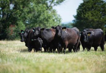
USDA Meteorologist Brad Rippey says the stubborn high heat that’s been in the south and southwest will push its way into the Midwest by mid-week. The growing season has been far from perfect, but the overall crop condition ratings have seen steady improvements in July. Last week’s U.S. Drought Monitor showed 55% of the U.S. corn crop and 50% of U.S. soybeans are covered in drought, an improvement from the 70% of corn and 63% of soybeans considered to be in drought the last week of June.
“It’s been a year full of challenges, no doubt about it,” says Rippey. “To this point, our biggest issues have been with the dryness that peaked in late June, and since then, we’ve seen considerable relief in some areas. But now for the first time, we're combining that with the highest temperatures of the season to date.”
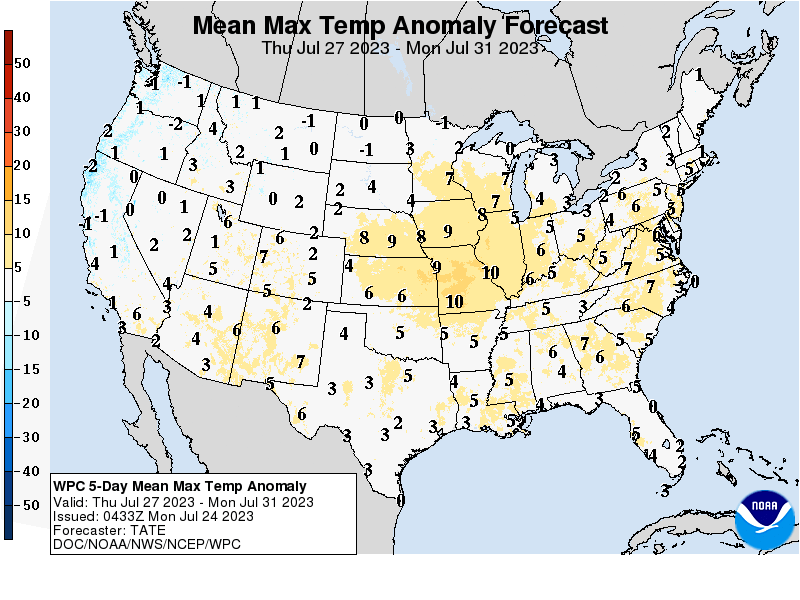
A map from NOAA shows areas of the country in for the most extreme conditions compared to normal. The areas of the Midwest in yellow will see temps 7 to 10 degrees above normal.
“We could see widespread temperatures 100 degrees or higher throughout the western Corn Belt, extending eastward into the Mississippi Valley, and so the areas like Missouri where we really haven't seen much recovery, if any, this heat on top of the dryness is coming in terrible time. We have corn and soybeans that are in the reproductive to filling stage, which it's absolutely critical to keep temperatures and keep the moisture coming in during this time. We have neither in the driest areas right now,” says Rippey.
Western and Central Corn Belt Could Be Hit the Hardest
Rippey says the current forecasts indicate the extreme heat won’t initially hit the eastern Corn Belt. He says those areas will see temperatures in the mid-90s, but the western Corn Belt is bracing for consecutive days of temperatures above 100 degrees.
“You've got to really focus on that southwestern Corn Belt area as the biggest concern, because if you look at Missouri, and parts of neighboring states, we've got much deeper problems than this week's heat; we have the moisture deficiency, and we have the drought issues that go back all the way into early spring," he says. "And so where we have those subsoil and topsoil moisture shortages in the southwestern Corn Belt, overlaying that with 100 degree heat this week, that is going to be another blow for corn and soybeans in those areas."
Heading into this week's Midwest heat wave, I wanted to post the current accumulated stress degree day map.
Calculated by adding degrees above 86°F for each day.
Example: if today is 95°F, 9 SDDs are accumulated
>140 SDDs could result in corn yield loss
Data: PRISM April 1 pic.twitter.com/ZdgxRfOEsH — Eric Snodgrass (@snodgrss) July 24, 2023
With the heat that’s been parked in Texas and across the Southwest this month, Eric Snodgrass, principal atmospheric scientist with Nutrien Ag Solutions, explains the duration of the heat is the biggest question. While the forecasts indicate the heat will last through the weekend, some weather models point to high temperatures returning next week.
“We're going to be talking about temperatures that are going to be in the mid- to upper-90s as far north as Minnesota and the Dakotas, and then possibly, there’s going to be some pockets in Missouri, Illinois, Nebraska, Kansas, that are going to be over 100 degrees Fahrenheit,” says Snodgrass. “And so we always worry it's going to last. Is this going to be a two-to-three-day event? Or is there going to be a 10-day event or a 30-day event?”
Hot with a Chance of Isolated Storms
He says the current thinking is the heat starts on Wednesday and then lasts through the weekend. There are some forecasts pointing to 105 degree heat in Iowa.
“But the question we have is, there's humidity in this pattern. So, will there be storms that blow up in the middle of this and bring some cooler weather? That's a possibility,” he says. “So, I would call it hot, hot with a lot of isolated storm activity. There's going to be winners out of this, and there's going to be a larger area that's going to see some crop damage.”
Rippey points out there are areas that have seen more than adequate rain this summer, including Oklahoma.
“It's incredible when you look at the last three months,” says Rippey. “We have seen upwards of 20 inches of rain in parts of Oklahoma, and even into southwestern Kansas. That is a year's worth of rainfall in three months. And it's also areas that were in some of the highest levels of drought just three months ago, at the end of the winter wheat season. So big turnaround for those folks.”
He says when you travel north and east of those areas, like into Missouri and Nebraska and even into Minnesota, that’s where the rains have been absent.
“We have seen a more recent trend toward drier weather in parts of the Upper Midwest. Minnesota really comes to mind as an area really short on rainfall the last several weeks,” says Rippey. “Even there, we're going to see temperatures creeping up into the 90s to near 100 this week. The crops are a little bit later in that part of the world, as you move into the northern Corn Belt, which means we're really at a critical time right now in terms of reproductive corn and blooming soybeans. If it turns cooler and wetter, soybeans still have a chance, but corn gets one chance to move through. So it’s really bad timing for upper Midwestern crops due to the heat this week, and the dryness that's been developing the last several weeks.”
Rippey says the current forecast indicates the central Midwest and into the South and Southwest will miss out on the chance for rainfall.
“Even though the Midwest will see sporadic showers, amounts will generally not be enough to keep up with high temperatures and peak crop-moisture demand. This could lead to increased stress on corn and soybeans, especially in hotter and more significantly drought-affected areas of the western Corn Belt,” Rippey says.
Snodgrass says Climate Prediction Center (CPC) August through October forecast indicates the ridge, which is causing the high heat to enter the Midwest this week, gets shoved back West in August, which will keep the Midwest much cooler in August. CPC also thinks El Nino takes over and it turns wet, but Snodgrass says he’s not sold on that forecast, as all the weather models still have conflicting forecasts.
"I feel like we've been punched in the mouth twice. And if there's a third punch, maybe it's, you know, longer duration into early August, and I think we're going to see some possible significant yield loss. But if storms cascade over the top of it, and the ridge goes back to Arizona, then we will be talking about busting bins with yield," Snodgrass adds.