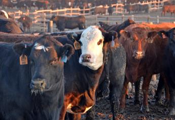
Flooding Kills Estimated 300,000-plus Cattle in Australia
Record rain fall in northern Queensland, Australia has left upwards of 300,000 cattle dead as farmers struggle to care for their livestock during a multiday rain storm.
After years of drought, the northeastern region of Australia received much needed rain towards the end of January and the start February. However, the rain was more what is typically expected in the area during a single year and led to widespread devastation.
“We think that there’s over 300,000 head of cattle that have been lost, drowned or washed away,” says Georgie Somerset, president of the farm lobby group AgForce.
Queensland is home to approximately 11.1 million head of cattle, about 42.5% of Australia’s cattle, according to Australian Bureau of Statistics and Australian Government Land and Coasts. The current estimated death toll would mean one out 37 cattle in the state have been killed. Other estimates from a number of media outlets in Australia have put the death toll at up to 500,000 head of cattle.
According to AgForce, the area impacted is twice the size of Tasmania (or West Virginia) at 32.74 million acres (13.25 million hectares).
In an interview with ABC News, 4th generation cattle farmer Dudley Harrington shares his experience dealing with flood waters on his station.
“About two weeks ago the rain started here which was very welcomed after we’ve gone through about seven tough years of drought here,” Harrington says.
Unfortunately, for 11 days it rained at Harrington’s cattle station with relentless winds blowing around 40 miles/hour (65 km/hour) and with the temperature dropping it made it difficult on livestock. During breaks in the storms Harrington would fly in a helicopter to drive cattle towards higher ground and drop hay from the air.
Harrington is unsure of the losses on his station or the extent of the damage. He has only been able to leave the homestead via a helicopter and has observed that much of his fence has been destroyed.
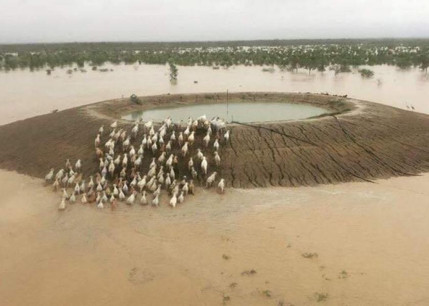
“There are a lot of cattle that have perished in the paddocks just because of the chilly winds and extensive rain. There have been a lot wash away because it has been such a widespread flood,” Harrington says. He adds that areas he has seen are as wide as 53 miles (85 km) with no land in between.
Large cattle stations like Australian Agricultural Company Ltd (AACo) have experienced significant cattle losses because of the flooding. AACo owns nearly half a million cattle running on 24 stations throughout Australia and four of those properties were impacted by the storms.
Losses at the 600,000 acre Wondoola station have been extreme according to Hugh Killen, AACo managing director.
“We’ll have to see what happens over the coming days and weeks, but it looks grim for those cattle,” Killen says.
The Canobie, Dalgonally and Carrum stations also had high losses. “We haven’t disclosed the breakdown of numbers across those three properties, but it's been a pretty tough one on Dalgonally,” Killen says.
There have been efforts underway to give support to cattle farmers in Australia via hay donations. These efforts have been put together by groups like the Australian Defence Force, local government, AgForce and Australia’s Department of Agriculture and Fisheries.
Queensland’s Department of Agriculture and Fisheries has enacted an assistance funding program that offers up to US$53,000 (AUS$75,000) in grants to aid farmers. The grants can be used for hiring and leasing of equipment, purchasing hay, replacing dead livestock, salvaging feed or crops and repairing essential plant and equipment.
The government is also being flexible with its rules regarding the National Livestock Identification System (NLIS) during this time of natural disaster for impacted cattle producers.
Queensland’s Bureau of Meteorology calls the flooding along the Flinders River – Queensland’s longest river – the most significant that has been witnessed in more than 50 years.
Below are some social media posts showing the devastation and rescue efforts going on in Australia (Warning: Some of the images are graphic in nature):
River levels continuing to rise in the lower Burdekin River into tomorrow. Roughly 16,000 cubic metres of water is currently flowing over #BurdekinFallsDam every second, the equivalent of 16,000 fully grown salt crocs being flushed down the river every second #qld #floods ? pic.twitter.com/eShqcPH2FW — Bureau of Meteorology, Queensland (@BOM_Qld) February 7, 2019
These cattle in Cloncurry are dry and safe - it’s thousands of others around Richmond, Hughenden and other centres across NW Qld that are stranded in water and unable to access feed. We’re working with other levels of government to find the best way to drop fodder. pic.twitter.com/OoMwWcJuJd — Annastacia Palaszczuk (@AnnastaciaMP) February 7, 2019
Timelapse shows train line engulfed by rising flood waters in Corella Creek, Queensland, Australia. The footage was captured from 30 January to 5 February during the north Queensland floods. Hundreds of thousands of cattle are feared to have died in the area. pic.twitter.com/QFHlrLT5gM — BBC Weather (@bbcweather) February 8, 2019
Flood plumes entering the ocean near #Ayr are clearly visible from Japan's Himawari-8 weather satellite. Levels on the Burdekin River are expected to ease below the minor flood level overnight tonight. See Warnings for further info: https://t.co/CQJkcamqzO pic.twitter.com/EEnJuGFnkz — Bureau of Meteorology, Queensland (@BOM_Qld) February 12, 2019
False-colour images of #flood waters in #Queensland taken from Japan's Himawari-8 satellite. Major flooding is occurring now on the #DiamantinaRiver at Diamantina Lakes and downstream during the coming weeks. See Warnings for further info: https://t.co/reR9XrAPYW #bigwet pic.twitter.com/W1h8je9WD8 — Bureau of Meteorology, Queensland (@BOM_Qld) February 10, 2019